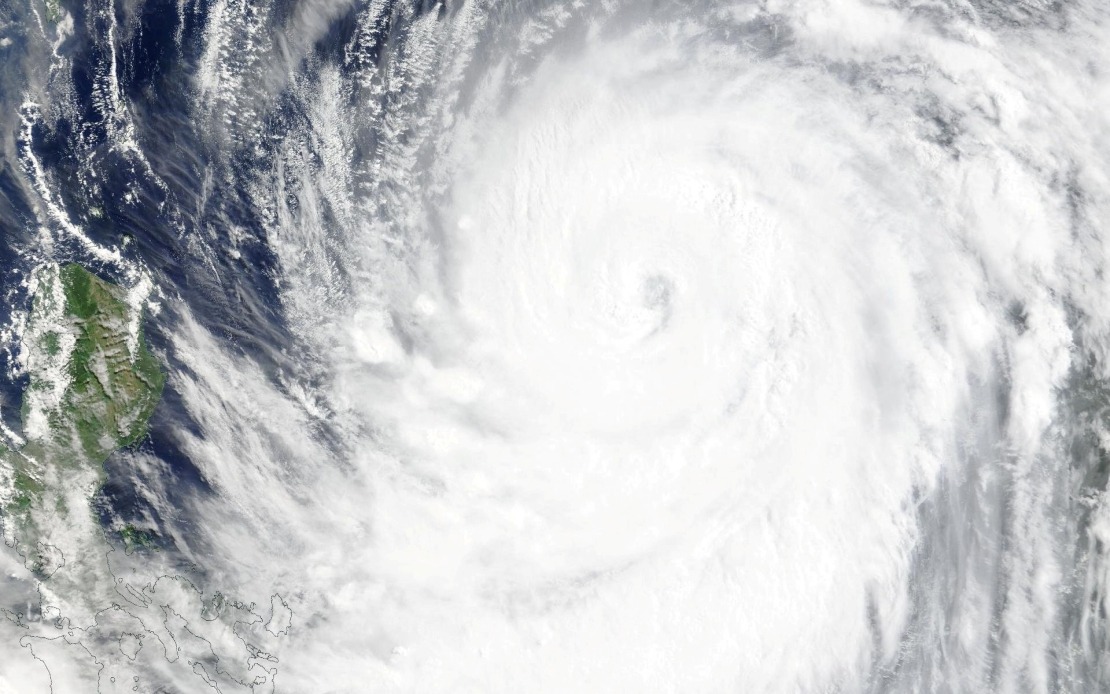
Taiwan's Central Weather Administration activated a sea warning on Thursday afternoon as Typhoon Bavi intensified while advancing toward the island nation, signalling the approach of what could be a significant weather event for the region. The ninth major tropical cyclone to emerge in the Western Pacific this year, Bavi has been tracking steadily closer to Taiwan's coastline, prompting authorities to escalate preparedness measures and issue increasingly specific guidance to the public.
The maritime warning issued at 2:30 pm local time covered a broad area encompassing the northeastern and southeastern waters adjacent to Taiwan, extending to encompass Orchid Island and Green Island as well as the strategically important Bashi Channel. This waterway, which separates Taiwan from the Philippines, represents a critical shipping corridor for regional maritime traffic. The geographic scope of the warning underscored the broad impact the storm was expected to generate across Taiwan's maritime approaches, rather than being confined to a single coastal region.
At the time of the announcement, Bavi maintained a position southeast of Eluanbi, Taiwan's southernmost extremity, while tracking in a northwesterly direction. The storm's centre was generating maximum sustained winds of 51 metres per second, with violent gusts peaking at 63 metres per second. These wind speeds positioned Bavi at a dangerous intensity level, capable of inflicting substantial structural damage and creating hazardous conditions across affected areas. Meteorologists anticipated the typhoon would maintain a northwest trajectory at forward speeds between 15 and 20 kilometres per hour, a pace that would bring it into close proximity with Taiwan within a brief timeframe.
Forecasters from the weather administration projected that Bavi would pass to the north of Taiwan proper, potentially affecting the island with the characteristics of either a lower-intensity strong typhoon or an upper-intensity moderate typhoon. This dual-scenario assessment reflected the uncertainty inherent in typhoon prediction, as even minor variations in atmospheric conditions could push the storm into the stronger or weaker category. For Taiwan's population and infrastructure, this range represented the difference between significant disruption and potentially severe damage, making the distinction far from academic.
The approaching storm had already begun exerting tangible impacts on the region's transportation infrastructure even before making landfall. Cross-strait air services between Taiwan and Japan's Okinawa Prefecture experienced widespread cancellations, with most scheduled flights between the two destinations grounded as a precautionary measure. Beyond these regional routes, several long-haul international flights originating from or transiting through Taiwan faced disruption, reflecting how far-reaching typhoon impacts could ripple across aviation networks connecting the broader Asia-Pacific region.
Beyond aviation disruptions, maritime transport equally felt the storm's approach. Multiple ferry services connecting Taiwan to outlying islands and regional ports suspended operations, a standard precaution when typhoons threaten. Transportation administrators also heightened alert status for Taiwan's mountain roads, recognizing that the extreme rainfall typically accompanying typhoons could trigger landslides and flooding in elevated terrain. These cumulative transportation disruptions illustrated how natural disasters of this magnitude cascade through interconnected systems, affecting not only immediate coastal populations but also supply chains, commerce, and logistics networks across the wider region.
For Malaysian readers, Typhoon Bavi's progression held particular relevance, as the storm's track and intensity could potentially influence weather patterns affecting Malaysia and Southeast Asia. The Bashi Channel, explicitly mentioned as falling within the warning zone, represents a strategically vital waterway for regional shipping, including Malaysian maritime commerce. Any sustained disruption to traffic through this channel could have downstream effects on intra-regional trade flows and logistical networks that Malaysian businesses depend upon.
The timing of Bavi's arrival also merits consideration within the broader context of typhoon seasonality in the Western Pacific. As the ninth typhoon of the year, Bavi arrived well within the typical peak season for tropical cyclone development in this region, when warmer ocean temperatures and favourable atmospheric conditions converge to sustain storm formation. The frequency of typhoons during this period underscores the inherent vulnerability of Taiwan and other Western Pacific territories to repeated weather disruptions throughout the monsoon and typhoon seasons.
Taiwan's meteorological infrastructure and early-warning capabilities have become increasingly sophisticated, reflecting decades of experience managing typhoon threats. The issuance of sea warnings substantially in advance of expected landfall timing demonstrates the operational coordination between forecasting agencies and emergency management authorities. For Taiwan's residents and businesses, such advance warning provides a critical window to implement protective measures, secure vulnerable assets, and adjust operational schedules accordingly.
The escalation pathway from sea warnings to anticipated land warnings underscores the systematic approach Taiwan employs when confronting typhoon threats. This graduated warning system allows authorities to tailor their advisory messaging to specific risks faced by different populations and sectors. Maritime industries receive immediate notice to secure vessels and alter routes, while inland residents and infrastructure operators gain time to prepare for the inland impacts they will eventually face.
For the broader region, Typhoon Bavi exemplifies the interconnected nature of weather systems across the Western Pacific and Southeast Asia. While Taiwan faces the most immediate and severe impacts, the storm's influence radiates outward through atmospheric patterns, ocean conditions, and disrupted transportation networks affecting countries throughout the region. Malaysian weather services and maritime authorities would monitor Bavi's progression with interest, both to anticipate any secondary effects on Malaysian territory and to support regional disaster management coordination if circumstances warranted.

