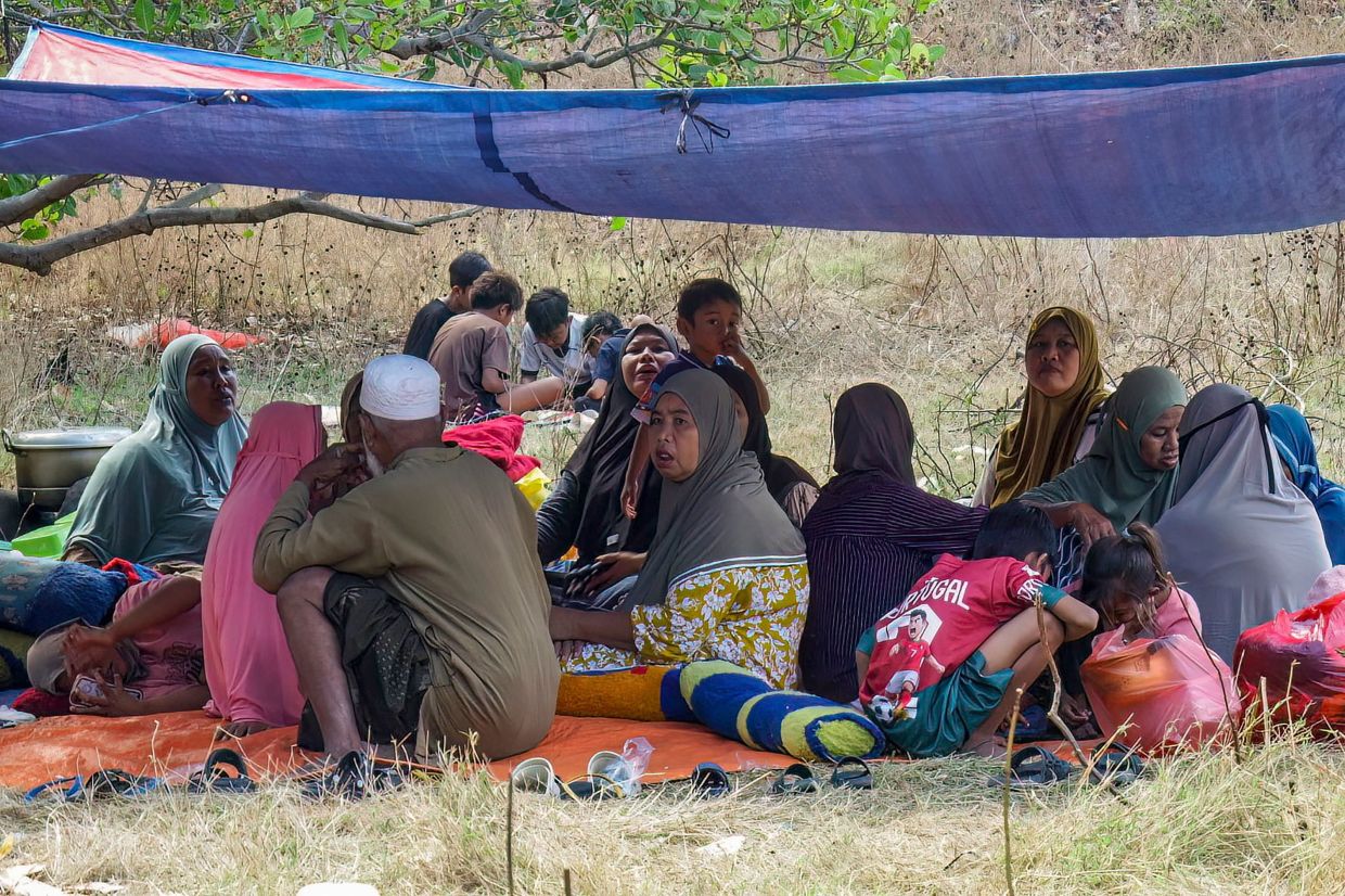
Thousands of displaced residents remained stranded on hillsides across Indonesia's Flores island on Sunday, awaiting emergency supplies after a devastating 7.7 magnitude earthquake claimed 48 lives and destroyed or severely damaged hundreds of structures. The powerful seismic event struck early Saturday morning off the northern coast, triggering approximately 341 aftershocks that continued to rattle the region throughout the day and into Sunday, according to Berton Suar Pelita Panjaitan, a spokesman for Indonesia's national disaster agency BNPB. The scale of displacement proved immediate and widespread, with some 5,000 people abandoning their homes within hours of the initial tremor as panic and fear of structural collapse gripped the island community.
The humanitarian situation on the ground remains precarious, with survivors describing acute shortages of essential resources. Umri, a resident of Nangahale village situated on Flores' northern coastline, articulated the desperation facing evacuees during an interview Sunday morning, emphasizing the critical need for food supplies, potable water, medications and infant care products. The 55-year-old had spent the previous 24 hours sheltering atop a hillside alongside other frightened residents who remained too apprehensive to attempt returning to their homes. The decision to remain in makeshift outdoor camps reflects both the structural integrity concerns surrounding partially damaged buildings and the psychological trauma triggered by powerful aftershocks that continued to shake the island well into Sunday.
Trauma from past disaster weighs heavily on survivors' minds, with many residents drawing haunting parallels to the catastrophic 1992 earthquake that devastated the same island. Nurhidayati, also 55 years old, spent an uncomfortable night on a woven mat alongside other displaced persons on the same hillside refuge. Speaking to journalists, she described the visceral fear that gripped her following Saturday's tremor, recounting how residents scrambled frantically uphill to escape potential danger. Her anxiety was compounded by vivid memories of the 1992 seismic disaster, which had registered an identical 7.7 magnitude and triggered a subsequent tsunami that killed approximately 2,500 people across the island. The prospect of returning to her home remained unthinkable for Nurhidayati, as ongoing psychological trauma from that earlier catastrophe continued to influence her behaviour and decision-making.
The physical devastation catalogued by disaster management officials paints a grim picture of infrastructure damage across the island. At least 914 residential structures sustained severe damage, whilst several hundred additional buildings experienced moderate harm that nonetheless rendered them temporarily uninhabitable. Beyond residential properties, the earthquake's destructive reach extended to critical public infrastructure, with 93 educational facilities, 36 health centres and 38 government offices all reporting significant damage. In certain areas, communications networks and electrical systems remain non-functional, creating additional challenges for both rescue operations and the distribution of humanitarian aid to isolated communities. At least one key access road serving the affected region remained impassable Sunday morning, further complicating logistics for rescue teams and aid delivery operations.
The official injury toll stands at a minimum of 101 people, with casualty figures potentially rising as rescue teams complete their assessment of damaged areas. Despite intensive search efforts continuing throughout Sunday, local search and rescue coordinator Fathur Rahman reported no confirmed cases of individuals buried beneath rubble or missing as of Sunday afternoon. This relatively positive finding suggests that while casualties remain tragically high, the earthquake did not produce the mass entrapment scenarios that occasionally accompany similarly powerful seismic events. The disaster agency spokesperson Berton stated in an official statement that beyond the immediate loss of life, the offshore earthquake generated widespread material destruction that has fundamentally disrupted the normal functioning of residents' daily lives and community activities.
The shallow depth of the earthquake's epicentre, positioned just offshore from Flores' northern coast, explains the intensity of ground shaking experienced across the island. Geological authorities confirmed the quake's location and noted that the affected region contains relatively few high-rise buildings, a factor that may have helped limit casualties compared to similar magnitude events in more densely constructed urban environments. The tremor's shallow origin also contributed to the remarkable frequency of aftershocks, with 341 documented tremors occurring in the immediate aftermath of the initial earthquake. This sustained seismic activity has prevented many residents from attempting to retrieve possessions or assess structural damage to their homes, as each new tremor raises genuine concerns about potential building collapse.
Initial emergency response measures have commenced, though the scale remains inadequate relative to identified needs. The Indonesian government mobilised 50,000 aid packages with a combined weight of 275 tonnes dispatched toward the affected region, representing a substantial initial relief effort. The International Federation of Red Cross and Red Crescent Societies announced preparations to establish temporary shelters and provide assistance to thousands of evacuees currently in emergency camps. Additionally, European Union Commission President Ursula von der Leyen announced the bloc's readiness to deploy Copernicus Earth observation satellites to support Indonesian search and rescue operations, offering technological assistance to supplement ground-based efforts. The East Nusa Tenggara provincial government, which encompasses Flores, initiated formal procedures to establish an officially declared emergency response status lasting 14 days, a designation intended to facilitate accelerated relief coordination and resource deployment.
The immediate aftermath of the earthquake saw alarming scenes as residents fled toward elevated terrain in response to unusual ocean behaviour. As the initial tremor subsided, many Flores residents noticed the sea receding from the shoreline—a potentially ominous sign of an approaching tsunami that prompted mass evacuation toward hills and higher ground. The geological agency BMKG subsequently documented wave heights reaching 1.6 metres in certain coastal zones, though the tsunami warning was eventually lifted as measurements indicated a diminished threat. Authorities nonetheless urged residents to avoid returning to structurally compromised buildings, warning that ongoing aftershocks could potentially trigger additional collapses in already weakened structures.
Flores' vulnerability to seismic catastrophe reflects Indonesia's broader geographical positioning within the Pacific Ring of Fire, an arc of extraordinarily active seismic zones stretching from Japan southward through the Indonesian archipelago and across the Pacific basin to North America. The Indonesian nation experiences frequent earthquakes as a consequence of this tectonic reality, with most significant seismic events generated by the collision and subduction of oceanic plates beneath the Asian continental plate. The 2004 Indian Ocean earthquake demonstrated the region's potential for truly catastrophic seismic events, when a 9.1 magnitude tremor struck off Sumatra's coast and generated a tsunami that claimed approximately 220,000 lives throughout the region, with approximately 170,000 fatalities occurring within Indonesia alone. That event remains ranked among the deadliest natural disasters in recorded human history, establishing a stark precedent for understanding the genuine hazards that archipelago residents routinely face.

