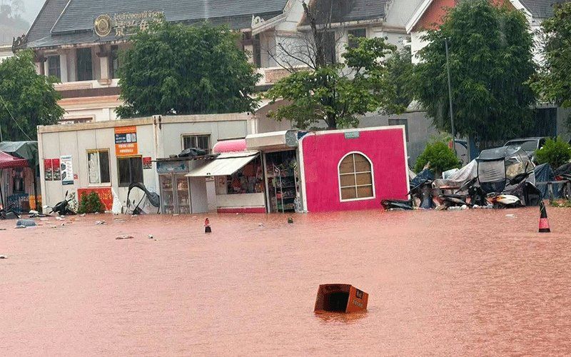
Northern Laos has formally declared Luang Namtha province a disaster zone following destructive flash flooding that engulfed the Boten border crossing with China and surrounding communities on Saturday. The Luang Namtha Provincial Administrative Committee issued the declaration after rapid rivers and heavy rainfall overwhelmed the region, causing widespread damage across more than 30 villages in addition to flooding a special economic zone, critical infrastructure facilities and extensive farmland. The disaster underscores the growing vulnerability of border communities in Southeast Asia to extreme weather events, particularly as climate patterns shift and development accelerates in sensitive geographic zones.
The deluge swept through Luang Namtha and Nalae districts with particular force, submerging structures situated near watercourses, damaging an airport facility, and inundating schools and hospitals that serve as essential community anchors. Large stretches of cultivated land lay underwater, threatening local agricultural productivity and food security for rural populations dependent on seasonal harvests. The scale of the flooding captured by local administrative reports indicates a disaster of significant regional consequence, though the border checkpoint itself escaped direct inundation—a fortunate outcome given the economic importance of the Laos-China crossing for trade and commerce.
Hydro-meteorological data revealed the magnitude of the crisis unfolding in real time. A monitoring station along the Tha River recorded water levels reaching 6.58 metres on Saturday, surpassing the 6-metre alert threshold established by water management authorities and approaching the 7-metre mark designated for severe flooding. This rapid ascent reflected the combined effect of prolonged heavy rainfall in upstream catchment areas and the steep topography characteristic of northern Laos, which channels water quickly downslope toward inhabited valleys. The Department of Meteorology and Hydrology under the Ministry of Agriculture and Environment responded by issuing formal flood warnings for the Tha River spanning the 29th and 30th of August, signalling continued danger in the period immediately following the initial surge.
Civilian preparedness and emergency response mobilised swiftly following the disaster declaration. Provincial administrators issued orders to five districts to activate alert protocols for residents dwelling along river corridors, in topographically low zones and other high-risk locations. Communities received guidance on readiness measures and potential evacuation procedures should water levels continue their upward trajectory. This layered approach to disaster management—combining real-time monitoring, advance warning systems and pre-positioned evacuation frameworks—reflects international best practice in flood risk mitigation, though implementation challenges remain acute in remote rural settings with limited infrastructure.
Local governance structures intensified oversight of the unfolding crisis. Officials across affected districts received explicit instructions to maintain continuous environmental surveillance, respond promptly to emerging incidents and furnish regular situation reports to provincial command centres. This emphasis on real-time communication and rapid incident response seeks to compress the reaction window between hazard detection and protective intervention, potentially reducing casualties and losses. The coordination burden falls particularly heavily on provincial authorities managing multiple simultaneous crises across geographically dispersed communities with varying resource capacities.
The Luang Namtha crisis sits within a far broader meteorological system generating hazards across the northern region. A low-pressure weather system tracking southeastward from southwestern China, when combined with the prevailing southwest monsoon circulation, was forecast to trigger scattered thunderstorms, moderate-to-heavy precipitation and forceful wind gusts affecting a 14-province swath of northern and central Laos through the weekend period. This macro-scale atmospheric pattern indicates that the Luang Namtha flooding represents merely the leading edge of a more expansive weather event with potential consequences across the northern tier of the country.
The vulnerability footprint extends across Phongsaly, Huaphan, Luang Prabang, Luang Namtha, Oudomxay, Xaysomboun, Bolikhamxay, Khammuan, Savannakhet, Salavan, Xekong, Champasak, Attapeu and Vientiane provinces—a roster encompassing nearly all significant population centres in Laos north of the capital. Authorities issued general alerts to populations occupying riverbank settlements and low-lying terrain, advising heightened vigilance, close monitoring of official weather bulletins and preparatory measures against both inundation and secondary hazards including rainfall-triggered landslides. For Malaysian and regional observers, the event illustrates how extreme weather increasingly impacts critical border infrastructure and cross-frontier economic corridors throughout Southeast Asia.
The Boten border crossing represents a significant economic artery facilitating bilateral trade and investment flows between Laos and China. Its functioning depends on robust road and rail networks, customs facilities and logistics infrastructure—all elements vulnerable to water damage and erosion during major flood events. When such disasters strike border regions, the ripple effects extend beyond national boundaries, potentially disrupting regional supply chains and commerce patterns that increasingly integrate Southeast Asian economies with major Asian powers. The preservation of critical cross-border infrastructure thus carries implications for regional economic stability beyond the immediate humanitarian crisis.
Luang Namtha province has long occupied a strategic position within Laos's development framework, hosting special economic zones designed to attract foreign investment and generate employment. Flooding in such zones threatens not only immediate economic activities but also investor confidence in climate resilience and governance capacity. For Malaysia and other ASEAN nations engaged in intra-regional infrastructure projects and investment ventures, the Laos experience provides cautionary lessons regarding the necessity of integrating climate adaptation and disaster resilience into development planning and project design. The absence of such considerations risks creating stranded assets and lost economic opportunities as extreme weather events become more frequent and intense.
The broader meteorological pattern driving the Luang Namtha flooding reflects climate dynamics increasingly familiar to Malaysian weather specialists and disaster management authorities. The interaction between tropical low-pressure systems and monsoonal circulation patterns has long generated seasonal floods throughout the peninsula and throughout Southeast Asia more broadly. Yet contemporary climate change appears to be intensifying precipitation extremes and altering the predictability of traditional seasonal patterns, potentially rendering historical flood records and early warning thresholds progressively obsolete. Regional cooperation on meteorological science, data-sharing and early warning system harmonisation thus represents an emerging necessity for ASEAN states seeking to manage shared hydrological systems and transboundary flood risks.

