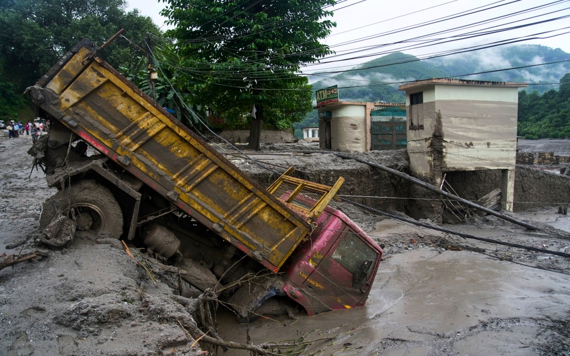
Nepal faces renewed danger from its waterways as the National Disaster Risk Reduction and Management Authority (NDRRMA) issued an urgent alert on Friday about rising water levels in the Bhote Koshi River. The warning comes just two days after a catastrophic flash flood devastated the same stretch of river in Rasuwa district on August 26, leaving hundreds dead and missing. Authorities detected a fresh surge of water laden with mud and debris flowing through the area, signalling the potential for another major inundation that could compound the humanitarian crisis already unfolding across the country.
The timing of this secondary warning underscores the unpredictable nature of mountain flood events in Nepal, where rapid snowmelt, glacial outburst floods, and monsoon-driven rainfall converge to create dangerous conditions. The Bhote Koshi, which originates in the high Himalayan region and flows through deeply carved valleys before joining the Trishuli River system, is particularly susceptible to such cascading disasters. The river's steep gradient and narrow riverbed mean that debris-laden flows can travel with tremendous velocity and destructive force, making even a single surge potentially lethal to communities downstream. That the same location experienced major flooding twice within 48 hours demonstrates how vulnerable the region remains and how quickly conditions can shift from relative stability to acute peril.
The NDRRMA's alert specifically cautioned all personnel engaged in ongoing rescue and recovery efforts along both the Bhote Koshi and Trishuli rivers to heighten vigilance and maintain readiness to retreat to higher ground. This directive reflects the operational challenges faced by rescue teams who must balance the urgency of searching for missing persons against the genuine threat to their own safety. Hundreds of people remain unaccounted for following the initial flood, and search efforts have intensified across multiple districts as teams comb through debris, check downstream areas, and investigate reports of sightings. The fresh warning forces difficult decisions about whether to continue combing dangerous riverbanks or suspend operations until water levels stabilise.
The death toll has climbed to 475 people, making this among the most devastating natural disasters Nepal has experienced in recent memory. The figure reflects not only the immediate destructive power of the initial flash flood but also secondary impacts such as landslides, infrastructure collapse, and limited access to emergency medical care in affected areas. Many of the missing are presumed dead, though hope remains for finding some survivors trapped in isolated pockets or sheltering in temporary refuges away from communication networks. The scale of loss has strained Nepal's disaster response capacity and stretched resources across government agencies, non-governmental organisations, and international assistance partners working to locate missing persons and support survivors.
For Malaysia and other Southeast Asian nations monitoring this crisis, Nepal's experience offers sobering lessons about monsoon-season vulnerabilities. While Malaysia faces its own seasonal flooding challenges in low-lying and urban areas, Nepal's mountainous terrain presents different but equally serious hazards. The Himalayas receive intense rainfall during monsoon months, and rapid runoff from steep slopes translates into dangerous floods that can travel considerable distances at high speed. Climate scientists note that changing weather patterns may increase the frequency and intensity of such extreme events, suggesting that preparedness systems across the region require continuous upgrading. The international community has recognised Nepal's particular vulnerability and provided technical assistance for early warning systems and community-based disaster risk reduction programmes.
The Rasuwa district, where the flooding originated, sits on Nepal's border with Tibet and historically experiences some of the country's highest precipitation levels. The area's rugged topography, limited road infrastructure, and scattered settlements complicate evacuation and rescue operations. Local communities have developed traditional knowledge about flood risks, often expressed through naming conventions and seasonal practices that reflect generations of living with water hazards. However, rapid environmental change, deforestation, and infrastructure development have altered watershed dynamics and flood patterns in ways that traditional knowledge alone cannot predict, underscoring the need for modern scientific forecasting combined with community engagement.
The infrastructure damage from the initial August 26 flood remains largely unquantified, but early reports indicate that bridges, roads, and water supply systems across multiple districts have suffered serious damage. These losses extend the disaster's impact well beyond immediate casualties, affecting the livelihood security and development prospects of communities dependent on functional transportation networks and utility systems. Reconstruction efforts typically require substantial external financing and technical expertise, creating opportunities for Nepal to strengthen building codes and infrastructure standards to better withstand future flooding. Regional bodies like the South Asian Association for Regional Cooperation have increasingly recognised the need for transnational approaches to managing shared river systems that cross borders.
The Trishuli River system, into which the Bhote Koshi flows, is shared with multiple countries and involves complex hydro-power development projects that also influence water management. These facilities can theoretically help regulate downstream flow but require careful operation during extreme rainfall periods to avoid compounding flooding. The August 26 disaster has raised questions about whether existing water management protocols are adequate for climate-changed conditions and whether regional agreements on water sharing need revision. These technical considerations will likely feature prominently in post-disaster assessments conducted by national and international experts.
Authorities have advised residents and relief workers to move to safer locations immediately upon observing any danger signs such as unusual water discolouration, rising noise from the river, or accelerating flow rates. These warning signs provide crucial minutes of lead time for evacuation, though their effectiveness depends on clear communication pathways and community familiarity with appropriate responses. Mobile phone networks and radio-based early warning systems have been deployed in recent years to improve alert dissemination, yet coverage remains inconsistent in remote areas. The fresh flood warning serves as a reminder that disaster preparedness requires sustained investment in communication infrastructure, staff training, and community education that persists between major events.

