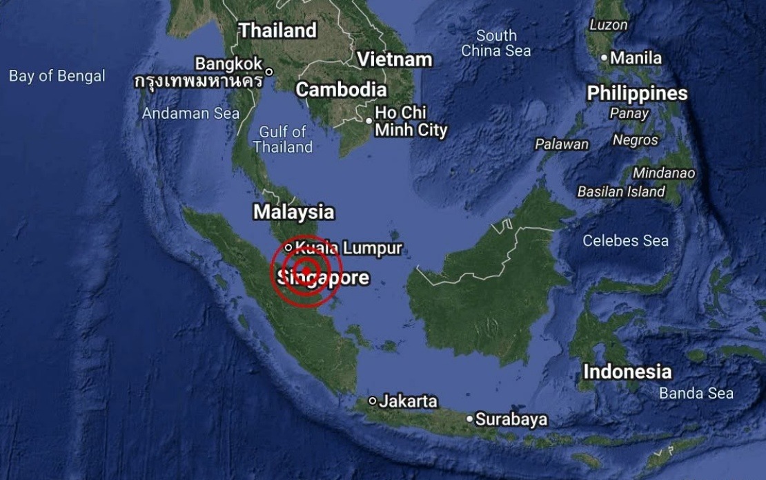
A minor earthquake with a magnitude of 3.1 rattled the coastal waters off Batu Pahat in Johor on August 25, occurring at 4.12 pm local time. The tremor, while detectable by seismic monitoring equipment, remained well below the threshold that typically causes damage to infrastructure or poses significant hazard to populations in the region. The Malaysian Meteorological Department (MetMalaysia) promptly issued a statement confirming the occurrence and assessing potential risks to the country's residents and maritime zones.
According to MetMalaysia's National Weather and Earthquake Operations Centre, the earthquake's epicentre was positioned at coordinates 1.7 degrees north and 102.8 degrees east, placing it approximately 18 kilometres southwest of Batu Pahat town in Johor's southern district. This location places the seismic event firmly within offshore territory, away from densely populated urban areas. The precise coordinates enable geologists and seismic specialists to map the event within the broader geological context of the Peninsular Malaysia region, where tectonic activity, though generally modest compared to zones along the Pacific Ring of Fire, does occur periodically.
The most significant aspect of MetMalaysia's assessment concerns the complete absence of tsunami risk to Malaysian waters and coastlines. This determination carries particular importance for a maritime nation like Malaysia, where coastal communities, fishing industries, and shipping traffic depend on accurate tsunami forecasting. The agency's swift communication ruled out the possibility that the offshore earthquake could have generated dangerous wave propagation, a concern that becomes relevant whenever seismic events occur beneath or near ocean surfaces. The absence of tsunami threat means that maritime activities, port operations, and coastal populations in Johor faced no disruption or evacuation requirements following the tremor.
Earthquakes of this magnitude are classified as weak on the Richter scale and typically produce effects that are only slightly felt by people in very close proximity to the epicentre. Most residents in Batu Pahat itself likely experienced no perceptible shaking, given the offshore distance and the moderate energy release. Such minor seismic events form part of the routine background activity that seismic monitoring networks worldwide record continuously. Malaysia's earthquake activity, while present, remains relatively subdued compared to neighbouring Indonesia or the Philippines, where tectonic plate boundaries generate considerably more frequent and powerful seismic events.
The role of MetMalaysia in earthquake detection and public communication underscores the importance of maintaining robust geological monitoring infrastructure. The department's National Weather and Earthquake Operations Centre maintains a network of seismometers across Malaysia and coordinates real-time analysis of earthquake data. This operational capacity allows authorities to provide timely information to the public, media, and relevant agencies, reducing public anxiety and enabling appropriate response measures when needed. The rapid issuance of a statement on the same day exemplifies this professional response framework.
For Malaysian readers, understanding the context of minor offshore earthquakes helps distinguish between events requiring concern and those representing normal geological background noise. The waters off Johor, as part of the broader Strait of Malacca region, sit within a geologically complex zone, yet modern seismic science has equipped researchers with detailed knowledge of local fault structures and seismic hazards. This scientific foundation enables authorities to make informed assessments about public safety rather than issuing generic precautionary advisories.
The incident also highlights the interconnected nature of earthquake monitoring across Southeast Asia. Neighbouring countries including Thailand, Singapore, and Indonesia maintain their own seismic networks, and international coordination protocols ensure that significant seismic events are quickly assessed for regional implications. A 3.1-magnitude earthquake off Johor's coast, while minor in absolute terms, forms part of the broader regional seismic picture that scientists continually analyse to refine understanding of crustal dynamics in the area.
For maritime industries operating in Malaysian waters, including commercial shipping, offshore petroleum operations, and fishing fleets, regular updates on seismic activity and tsunami assessments form part of standard operational risk management. The clear communication from MetMalaysia regarding the absence of tsunami threat allows these sectors to continue normal operations without interruption or excessive precautionary measures. This balance between vigilance and operational continuity reflects mature disaster management practice.
Looking forward, the accumulation of seismic data from events like this August 25 tremor contributes to long-term databases that scientists use to model earthquake frequencies and magnitudes in Malaysian waters. Over decades, such records help establish baseline patterns and identify any changes in seismic behaviour that might warrant deeper investigation. While a single 3.1-magnitude event carries minimal immediate significance, the cumulative record of such events informs the nation's broader understanding of geological hazards and helps guide land-use planning and infrastructure development decisions in coastal and near-coastal regions of Johor and other Malaysian states.

