The Malaysian Meteorological Department has issued an alert for severe weather conditions spanning multiple states across the peninsula, with thunderstorms, heavy rain and strong winds expected to continue until 3 am on June 29. The warning reflects the dynamic atmospheric conditions that frequently affect Malaysia during the monsoon transition periods, when moisture-laden air masses collide with topographical features to generate intense convective activity across vulnerable regions.
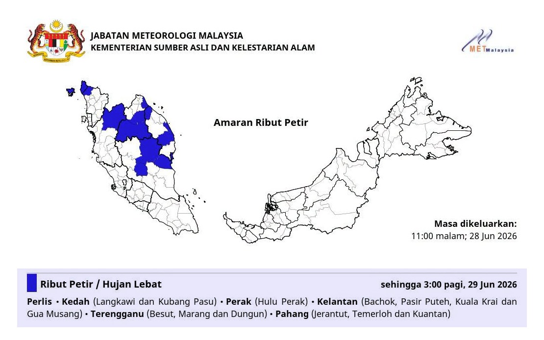
Perlis and Kedah are among the affected areas, with the latter facing particular risk in the Langkawi and Kubang Pasu districts. Both states, situated in Malaysia's northwestern corner, are prone to such weather systems given their exposure to maritime influences and the complex terrain of the Kedah-Perlis border region. The warning carries significant implications for fishing communities, maritime operators, and transport networks that depend on stable weather conditions during these hours.
In the east coast state of Perak, the warning specifically targets Hulu Perak, a mountainous and sparsely populated district where heavy precipitation poses risks of flash flooding in river valleys and disruption to road connectivity. This region's topography amplifies the danger posed by intense rainfall, as steep gradients can channel water rapidly into low-lying areas, potentially isolating rural communities and affecting agricultural activities that sustain the local economy.
Kelantan faces the warning across four distinct zones: Bachok, Pasir Puteh, Kuala Krai, and Gua Musang. This multi-district alert underscores the spatial extent of the weather system affecting the state, suggesting a broad-based meteorological phenomenon rather than a localized disturbance. Kelantan's historical vulnerability to flooding during monsoon periods makes such warnings particularly consequential for residents and authorities managing public safety and disaster preparedness.
Terengganu's affected areas—Besut, Marang, and Dungun—collectively represent a significant coastal and central corridor of the state. These regions experience variable exposure to severe weather depending on wind patterns and atmospheric pressure systems. Coastal districts face potential storm surge and rough seas alongside the terrestrial threats of flooding and wind damage, while interior areas confront primarily hydrological hazards from intense rainfall.
Pahang, Malaysia's largest state by area, faces warnings affecting Jerantut, Temerloh, and Kuantan. The inclusion of Kuantan, the state capital and a major commercial center, indicates that the warning encompasses urban and semi-urban zones where infrastructure disruption carries broader economic and administrative consequences. Temerloh's location astride the Pahang River means residents must monitor water levels closely during heavy rainfall episodes.
The geographic distribution of the warning—spanning peninsular Malaysia from north to south and east to west—suggests a significant atmospheric system influencing much of the country simultaneously. Such widespread patterns typically arise from monsoon troughs, inter-monsoonal convergence zones, or tropical depression systems that can maintain organization over extended periods. For Malaysian residents and officials, understanding the spatial coherence of such warnings helps contextualize the scale of the meteorological event and its potential impacts.
Thunderstorms accompany heavy rain with particular hazards including lightning strikes, sudden strong winds, and flash flooding in susceptible areas. The combination creates compounding risks: winds may down trees and power lines while simultaneously hindering drainage and emergency response capabilities; lightning presents acute dangers to outdoor activities and electrical systems; rapid runoff inundates low-lying infrastructure within minutes of rainfall onset. Communities in affected areas should remain alert to evolving conditions and heed any escalated alerts from authorities.
The early morning timing of the warning's conclusion—3 am—suggests the meteorological department's assessment that convective instability will diminish as nocturnal heating patterns weaken and atmospheric conditions stabilize. However, residents should recognize that warnings define expected hazard windows rather than absolute boundaries, and weather systems occasionally persist beyond predicted timeframes. Monitoring official channels for updates remains prudent practice, particularly for those in flood-prone areas or managing critical infrastructure.
For transportation networks, the warning implies elevated accident risk on affected routes due to reduced visibility, slippery road surfaces, and potential debris. Commercial and inter-state transport operators should exercise heightened caution, and travelers should consider delaying non-essential journeys through warned regions until conditions improve. Public utilities managing water supply and electrical distribution may also face service interruptions requiring contingency activations.
The Malaysian Meteorological Department's issuance of geographically specific and temporally defined warnings reflects advances in forecasting precision that allow authorities to target messaging to populations facing actual hazards rather than issuing blanket alerts. This specificity enables more proportionate public response and resource allocation. However, the number of districts encompassed in this alert—spanning six states across diverse geographic zones—underscores that portions of Malaysia frequently experience severe weather during monsoon and inter-monsoonal transitions, a pattern that shapes emergency preparedness strategies and infrastructure design standards throughout the country.