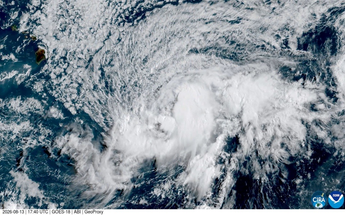
Hawaii's Big Island faces an uncommon meteorological threat this weekend as Tropical Storm Lala intensifies into a hurricane and closes in on the island, according to forecasters at the National Hurricane Centre. Officials expect the system to reach hurricane strength by Saturday as it approaches the island, creating conditions that could generate severe rainfall leading to flooding, alongside powerful winds capable of igniting or spreading wildfires across vulnerable regions.
The potential impact carries historical significance for the Hawaiian Islands. Should Lala make landfall on the Big Island, it would mark the first hurricane to strike the island since 1871, a gap of more than 150 years in recorded weather events. University of Hawaii atmospheric scientists have traced historical records through newspaper accounts from that era, confirming that a Category 3 hurricane struck the northeastern corner of the Big Island during the 19th century—a period long before modern satellite monitoring systems provided detailed storm tracking.
Metereologists with the National Weather Service in Honolulu emphasize the rarity of direct hurricane impacts on the Big Island. Vanessa Almanza, a meteorologist with the agency, noted that no hurricane has hit the island during the satellite era—a period spanning roughly 60 years of continuous atmospheric observation. The latest forecast models place Lala's potential track very close to the southern tip of the Big Island, representing a trajectory that brings the storm's most powerful core near populated areas.
The Hawaiian Islands chain now operates under escalated weather warnings across multiple jurisdictions. The Big Island itself is under a hurricane warning, indicating that hurricane-strength winds and associated hazards are expected within the warning area. To the northwest, Maui County has been placed under a tropical storm warning, affecting the islands of Maui, Molokai, Lanai, and Kahoolawe, all of which could experience significant impacts from the outer bands and moisture distribution associated with the approaching system.
For Malaysian and Southeast Asian readers, this weather event underscores broader patterns of tropical cyclone behaviour in the Pacific region. Hawaii's position in the central Pacific means the islands typically experience hurricane activity only during the region's peak season from June through November, yet direct landfalls remain statistically uncommon due to the island chain's relatively small geographic footprint in vast ocean expanses. The long gap between significant hurricane impacts creates particular vulnerability, as infrastructure, emergency response protocols, and community preparedness may not reflect recent experience with such events.
The dual threat posed by Lala—both flooding from torrential rainfall and wildfire risk from high winds—reflects the complex hazards that accompany tropical cyclones in Hawaii. Mountainous terrain on the Big Island channels rainfall into valley systems, amplifying flood potential, while strong winds can rapidly dry vegetation and accelerate fire spread across landscapes already stressed by drought conditions. Communities across the island have been mobilizing preparation efforts, securing loose objects, stocking supplies, and reviewing evacuation plans.
The forecast evolution of Tropical Storm Lala demonstrates how quickly weather systems can intensify in warm Pacific waters. The transition from tropical storm to hurricane status typically requires sustained wind speeds exceeding 74 miles per hour, a threshold forecasters anticipate Lala will cross well before reaching the islands. Sea surface temperatures across the central Pacific during August provide abundant energy for storm development, particularly in regions where atmospheric conditions favour organized convection and wind shear remains minimal.
Historical comparison provides perspective on how rare such events have become in modern Hawaiian experience. The 1871 hurricane that struck the Big Island's northeast section predates not only satellite observation but also most contemporary building codes, warning systems, and infrastructure standards now in place across the islands. Population distribution has shifted significantly since that era, with many communities now occupying coastal areas and lower elevations more vulnerable to storm surge, flooding, and wind damage.
Weather forecasters continue refining predictions as Lala approaches, with models occasionally showing variations in the system's precise track and intensity. Even marginal shifts in trajectory could determine whether the centre passes directly over the island or brushes close enough to deliver severe but not catastrophic conditions. Residents and officials are monitoring updates closely, preparing for the worst-case scenario while hoping for track shifts that might spare the Big Island from direct hurricane winds.

