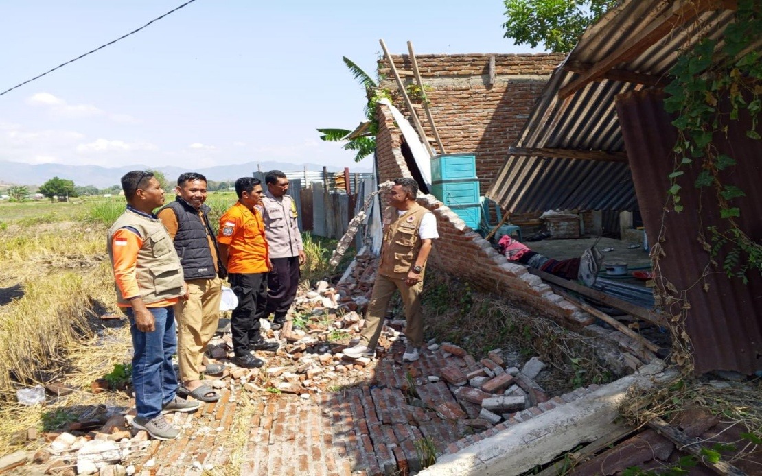
A severe earthquake measuring magnitude 7.7 struck Indonesia's Flores Island in the early hours of Saturday morning, setting off a cascade of emergency responses that displaced approximately 2,000 residents who either fled their homes or were moved to safety by authorities. The disaster struck at 4:58 am local time with its epicentre located roughly 30 kilometres offshore from Mbay at a shallow depth of 15 kilometres, a configuration that amplified the quake's destructive potential across populated coastal and inland areas of East Nusa Tenggara.
The initial tremor immediately triggered a tsunami warning from the Meteorology, Climatology and Geophysics Agency (BMKG), forcing residents to seek higher ground and creating panic across communities already reeling from powerful ground shaking. The agency later lifted the warning at 7:31 am after monitoring revealed that sea levels had stabilised without any significant further rise, allowing some displaced residents to tentatively return to assess their homes and possessions. However, the reprieve was short-lived, as the region experienced an extraordinary sequence of 111 aftershocks in the hours following the main event, keeping emergency services mobilised and residents in a prolonged state of heightened anxiety.
Berton Suar Pelita Panjaitan, the acting chief of the National Disaster Management Agency's (BNPB) Disaster Data, Information and Communication Centre, confirmed that the vast majority of residents had successfully reached safety, whether through official evacuation operations or through their own initiative prompted by the strong initial tremors. He emphasised that authorities were still in the process of fully comprehending the earthquake's impacts across the wider affected region, with field teams continuing to conduct systematic assessments across multiple jurisdictions.
Structural damage surveys conducted in the immediate aftermath revealed a sobering picture of the disaster's physical toll on communities. Preliminary findings documented 54 houses that sustained severe damage, 9 that suffered moderate damage, and 11 that experienced lighter structural impacts. Beyond residential buildings, the earthquake also affected critical public infrastructure, including five health facilities that serve vulnerable populations, one educational facility where children and teachers may have been endangered, three places of worship important to community spiritual life, a warehouse operated by Bulog (Indonesia's state food logistics agency), and six government office buildings that coordinate disaster response and essential services.
The Manggarai district, located on Flores, emerged as one of the most severely impacted areas, with field assessments identifying 29 heavily damaged houses alongside 9 moderately damaged and 9 lightly damaged structures. The neighbouring East Manggarai district also sustained substantial punishment, with at least 23 houses classified as severely damaged. These figures underscore the concentrated nature of seismic damage along Flores, where building construction standards and geological conditions combined to create particularly vulnerable communities.
Though initial death tolls from the Maumere Search and Rescue Office indicated 20 fatalities alongside six injured persons and two individuals trapped in collapsed structures, the full human cost of the disaster remained unclear at the time of initial reporting. The disparity between the number of displaced residents and relatively contained casualty figures suggests that the early morning timing of the earthquake, before many people had begun their daily activities, may have prevented even greater loss of life despite the magnitude and destructive energy involved.
Communications infrastructure across the Flores region suffered substantial disruption, with telecommunications authorities identifying approximately 200 base transceiver station (BTS) sites experiencing service failures across 10 separate districts and cities within East Nusa Tenggara. Wayan Toni Supriyanto, the Communication and Digital Affairs Ministry's Digital Infrastructure director-general, indicated that these damaged sites represented 16.35 per cent of all BTS infrastructure in the affected zones. The loss of mobile telecommunications capacity severely hampered both rescue coordination and resident ability to contact family members and seek assistance, forcing the ministry to urgently coordinate restoration efforts with mobile network operators.
The disaster highlighted the ongoing vulnerability of Indonesia's eastern regions to seismic activity, a consequence of the Indonesian archipelago's location along the Pacific Ring of Fire where multiple tectonic plates converge and generate frequent, often violent seismic events. Flores has historically experienced damaging earthquakes, making this event part of a recurring pattern rather than an isolated anomaly. The concentration of 111 aftershocks following the main shock reflected the ongoing stress adjustments within the fractured rock layers beneath the island, a process that can persist for weeks or months and keeps affected communities in a state of continued alert.
For Malaysia and other Southeast Asian nations, the Flores earthquake served as a stark reminder of the region's shared seismic risks and the importance of maintaining robust disaster preparedness infrastructure. The earthquake also demonstrated how rapidly coordinated multi-agency responses involving the military, police, local governments, and specialised disaster management agencies can mobilise to protect civilian populations, though the challenge of assessing damage, verifying casualty figures, and addressing the needs of displaced residents remains lengthy and complex. Regional cooperation mechanisms for disaster response, already established through various ASEAN frameworks, become increasingly critical as the frequency and severity of natural disasters continue to test the resilience of vulnerable island communities throughout Southeast Asia.

