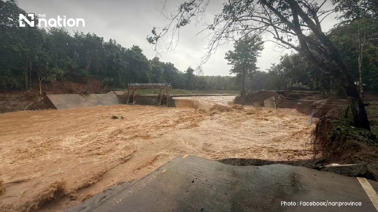
Torrential overnight rain has unleashed flash floods across Pua district in Nan province in northern Thailand, with the deluge washing away bridges, submerging homes and farmland, and severing crucial road connections. The waterlogged region recorded precipitation exceeding 110mm between Tuesday night and early Wednesday morning, a volume of rainfall that overwhelmed drainage infrastructure across the forested headwater areas and surrounding communities. Emergency responses were activated shortly after 6am when authorities confirmed the scale of inundation affecting residential zones, agricultural plots, and transportation networks throughout the district.
The particularly vulnerable Phu Kha subdistrict, characterized by its dense forest cover and elevated terrain, bore the brunt of the deluge. Data from the Doi Phu Kha National Park office documented the intensity of the precipitation, which generated rapid runoff cascading down hillsides into populated lowland areas. Residents had minimal warning and scant opportunity to protect their properties, with families scrambling to evacuate household items, electrical equipment, and pets to elevated positions within their homes or nearby structures. The speed and volume of floodwater overwhelmed local drainage capacity, transforming streets and agricultural fields into temporary waterways.
Damage extended across multiple communities, with Ban Rong in Pua subdistrict experiencing particularly acute inundation. The situation proved especially critical along routes connecting to Doi Phu Kha National Park and Bo Kluea district, where a bridge spanning what residents identified as Ban Na Lae simply washed away under the force of floodwater. Loss of this crossing has essentially severed access along that corridor, leaving communities on either side temporarily isolated and hindering supply deliveries and emergency response operations. A secondary bridge failure occurred at the Fai Chao weir area on the Doi Phu Kha route, compounding transportation difficulties across the district.
Hazards extended well beyond flooding, as geological instability triggered by saturated soil conditions produced multiple landslides across Ouan subdistrict. These earth movements blocked additional roadways, further restricting movement of personnel and equipment needed for rescue and relief efforts. Surveyors from Nan Highway District 2, operating under the Department of Highways, identified no fewer than three major locations where vehicular passage had become entirely impossible due to flood damage to road surfaces. Officials promptly issued public warnings advising travellers to avoid affected routes and suggesting alternative paths for essential journeys, though limited alternate corridors exist in this mountainous terrain.
Communications infrastructure deployed by the Department of Disaster Prevention and Mitigation proved instrumental in reaching residents across the flooded zone. Coordinating with mobile network operators AIS, True and NT, authorities activated the Cell Broadcast system to transmit urgent alerts directly to handsets within Pua district. The emergency message warned of ongoing heavy precipitation, imminent danger from flash flooding, risk of streambank overflow, and potential for additional landslides. Residents received explicit instructions to move valuables and essential items upward immediately and to relocate particularly vulnerable household members—elderly persons, bedridden patients, and small children—to safer locations without delay.
The alert also provided guidance on evacuation procedures and assistance channels, directing residents to contact their subdistrict administrators, village leaders, or local government offices for support. This decentralized approach leverages existing administrative networks and local knowledge to facilitate rapid response. District authorities had already begun mobilizing resources to reach isolated communities, though damaged road infrastructure complicated logistics considerably. The Nan Provincial Disaster Prevention and Mitigation Office maintained active monitoring of the unfolding situation and pledged to release updated information as conditions developed, recognizing that rain-swollen waterways and saturated ground posed continuing hazards.
Weather tracking by the Northern Meteorological Centre revealed that precipitation systems detected by Lamphun radar extended across nine provinces throughout upper northern Thailand. Rain bands visible on meteorological instruments were advancing southwestward, suggesting that additional areas downstream could expect heavy falls in coming hours. This broader regional pattern indicates that Nan province's flooding may not represent an isolated incident but rather part of a larger weather system affecting multiple jurisdictions. Adjacent provinces and downstream communities along the same river systems face potential secondary flooding as water accumulated in upper reaches drains toward lower elevations.
The timing of this disaster carries particular significance for rural communities dependent on agricultural output. Damage to farmland during the growing season disrupts seasonal cycles and threatens food security for both household consumption and regional markets. The destruction of bridges and road damage isolates farm communities from urban markets and limits access to agricultural inputs, veterinary services, and technical assistance. Recovery will require substantial public investment in infrastructure repair alongside support for farmers assessing crop and livestock losses.
For Malaysia and other Southeast Asian nations, the incident underscores the vulnerability of upland and forested regions to extreme precipitation events increasingly associated with monsoon variability and climate pattern shifts. Thailand's experience demonstrates the cascading consequences when rainfall intensity exceeds the design capacity of existing drainage and road infrastructure. Communities dependent on mountain passes and river crossings discover how quickly natural disasters can sever economic and social connections, a sobering reminder of regional infrastructure resilience challenges as extreme weather becomes more frequent.

